
 February 01, 2026 - POR Administrador
Santa Lucía (Lampa, Puno):
Solar Hole,
Cayachira Rock
and Cayachira Waterfalls
through a scientific lens
In the southern Peruvian highlands, the district of Santa Lucía (province of Lampa, Puno region, Peru) brings together high-mountain landscapes where geology and hydrology become visible “at first glance”: a circular lagoon known as Solar Hole, a massive rock formation called Cayachira Rock, and the Cayachira waterfalls, a cascade that sculpts the rock with millennial patience. Santa Lucía was created in 1936 and covers an extensive high-Andean area; its tourism offer includes precisely these attractions.
The attached video shows the location by zooming in on Google Earth and then presents (i) panoramic shots of the district and high-Andean plains, (ii) the Solar Hole in lateral and top views, (iii) the Rock with its vertical wall and a cave at the base, and (iv) a narrow waterfall that flows into a pool of clear water. This sequence allows the territory to be “read” as if it were a field notebook.
Where is Santa Lucía located and why is it special?
Santa Lucía is a district in Puno, in the province of Lampa, along the road corridor that connects the highlands with the Arequipa region. Its surroundings are characterized by open plains, very clear skies, and thermal contrasts typical of high altitude. In addition, in the community of Cayachira there are several local tourist attractions, including the Solar Hole, the Rock, and waterfalls.
In the field, this translates into:
• Transparent atmosphere and strong light (ideal for photography and observing landforms)
• Puna landscape with low tree cover (geology is exposed)
• Cold and dry environments with seasonal rainfall pulses (key for waterfalls)
The Solar Hole: a “circular lagoon” and hypotheses about its origin
The Solar Hole (also locally referred to by traditional names) stands out for its almost circular shape and for the water surface that reflects clouds and sky. In news media, its location at high altitude (around 4,045 m a.s.l.) has been reported, along with stories linking it to extraordinary phenomena. A common idea in oral tradition is that it could be the trace of a meteorite impact; however, that explanation does not have officially published geological evidence to confirm it.
From a superficial scientific perspective, there are several possibilities compatible with circular forms in the highlands: (1) depressions caused by dissolution/collapse processes in favorable rocks, (2) former excavations or quarries that have naturalized, (3) landforms associated with volcanic or glacial dynamics in the high-Andean region. What is interesting is that the Solar Hole shows a well-defined rim and a stable basin, suggesting a water balance that is maintained at least part of the year.
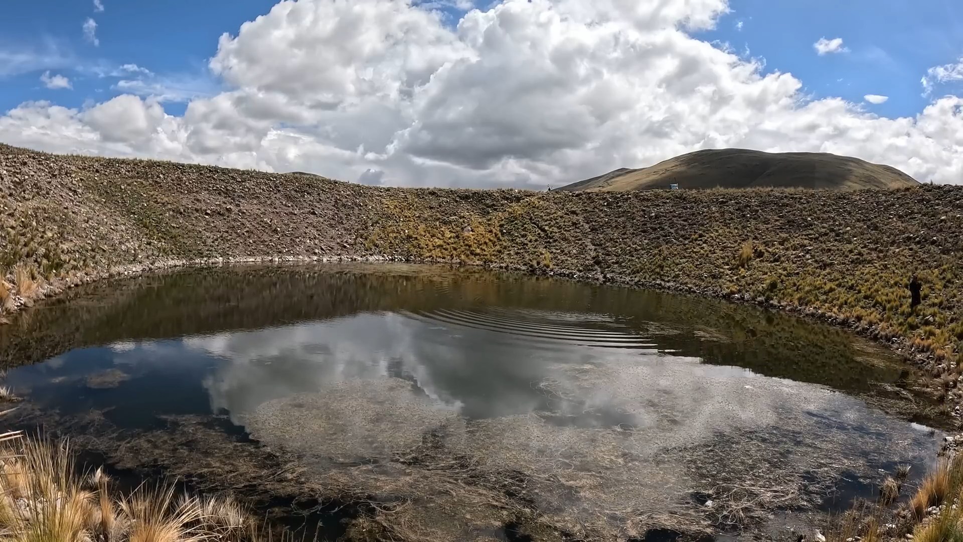
Solar Hole: Photo August 2025
Cayachira Rock: vertical wall, basal cave, and a “mark” on the landscape
The Rock appears as a large isolated rocky mass dominating the surroundings, acting as a natural landmark. In the video, a nearly vertical wall with textures and striations can be seen, as well as a cavity/shelter at the base that, according to local descriptions, can be used as livestock refuge. These types of forms are usually associated with the combination of resistant lithology + differential erosion: the rock “survives” while its surroundings wear away.
🔹 Geological interpretation (without losing the tourism perspective)
In areas of Puno/Lampa, Cenozoic volcanic and sedimentary units and regional fault systems have been described; this context helps explain why rocky walls, fractures, and narrow canyons appear. In the video, discontinuities and color changes suggest mineralogical variation and zones of weakness where water and ice accelerate shaping processes.
🔹 What is seen in the video
• Map-style sequence (Google Earth) marking the route to the “Rock”
• Wide shot of the massif with meadow at its base
• Detail of the basal cave (shelter) and the textured wall
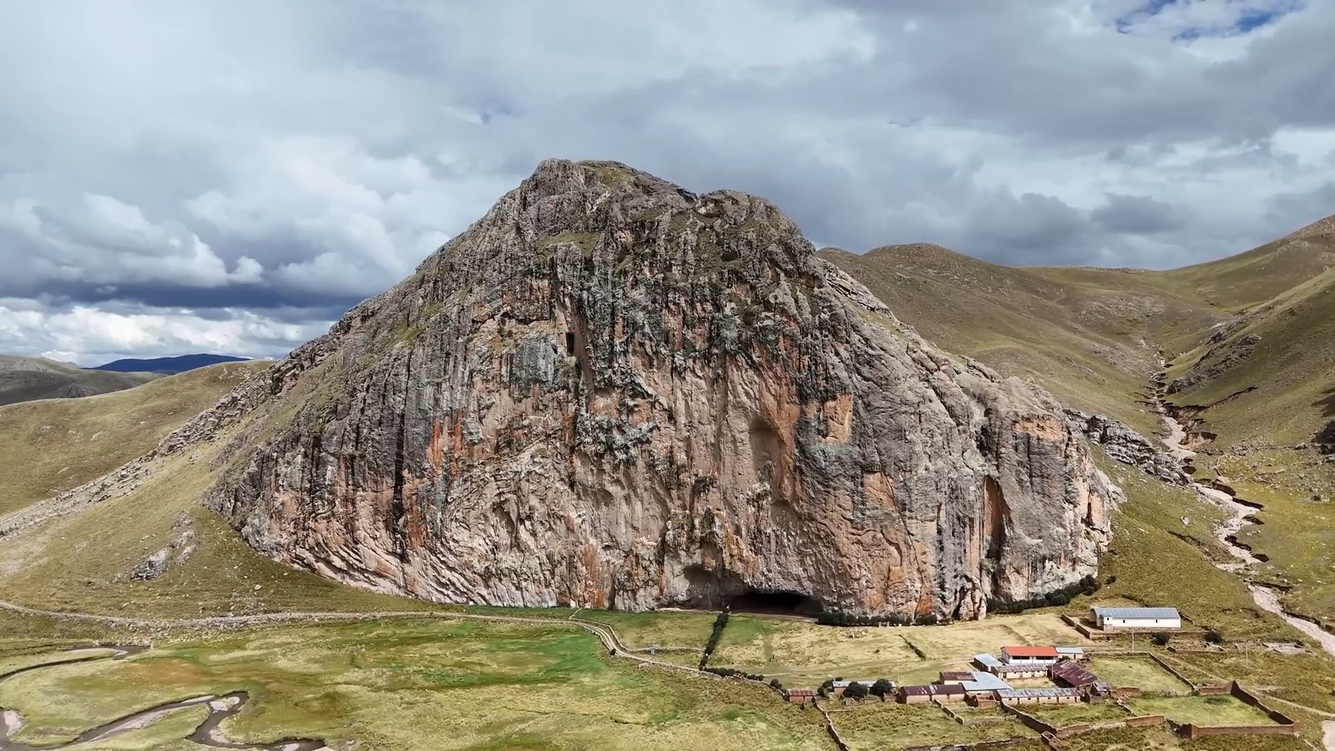 Cayachira Rock: Photo August 2025
Cayachira Waterfalls: the energy of water and canyon sculpture
The Cayachira waterfalls appear at the final stretch of the route as a narrow fall between rocky walls, feeding a relatively calm pool of water. Local news reports have described this waterfall as having notable height (dozens of meters are mentioned) and access from Santa Lucía with a short vehicle ride and a final hike.
From a scientific angle, a waterfall is a “geomorphology laboratory”: the potential energy of water becomes kinetic energy, impacts the base, and excavates a plunge pool. The fine mist (aerosols) observed in the video accelerates rock weathering and favors humid microhabitats in an otherwise generally dry environment.
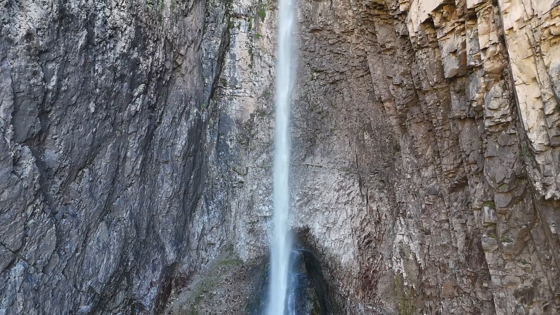
Cayachira Waterfall: Photo August 2025
Suggested route and recommendations (“light expedition” mode)
The most practical way is to depart from the town of Santa Lucía toward the community of Cayachira with local support. At high altitude, the weather can change quickly: intense sun at midday, cold wind, and marked shadows at sunset. For a safe and photogenic visit:
🧭 Coordinate with a guide/community (respect access and timing)
🧥 Dress in layers: windbreaker + warm clothing + hat
💧 Bring water and UV protection (altitude = stronger radiation)
🥾 Footwear with good grip (wet rock near the waterfall)
♻️ Zero waste: what goes up with you, comes down with you
Why is this circuit so photogenic?
Because it combines three powerful visual phenomena (circular geometry, rocky verticality, and water dynamics) within the same district.
